New Zealand
Thunderstorms set for both islands as Cyclone Vaianu moves away from NZ


Published by Sophie van Soest
13 Apr 2026
Cyclone Vaianu might be moving away from Aotearoa, but the rest of the country still isn’t in the clear just yet.
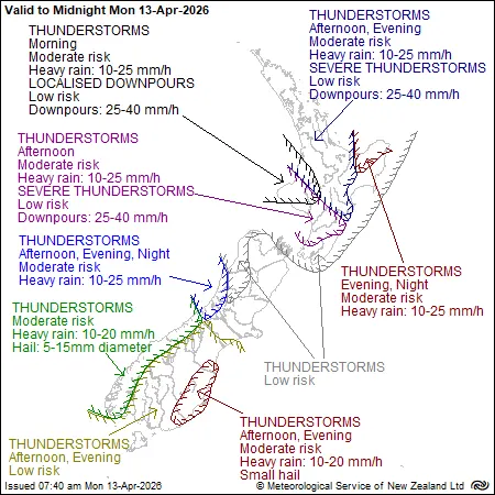
MetService says a series of fronts are moving across the motu, bringing thunderstorms, heavy rain and cooler temperatures for our Monday - particularly in parts of the North Island.
North Island
For the North Island, Metservice reports a moderate risk of thunderstorms for much of the North Island with heavy rain 10 to 25 mm/h, along with a low risk of downpours boosting localised rainfall rates to 25 to 40 mm/h.
From Northland to Whanganui, including the Coromandel Peninsula, Bay of Plenty and the central high country, showers are expected to spread in from the west this morning. These will become heavy at times, with possible thunderstorms developing later in the day.
Along the east coast, from Gisborne to Wairarapa, there will be some fine spells to start. However, scattered showers are expected to develop in the afternoon, with a chance of thunderstorms around the Tararua District.
The strong westerly winds in exposed areas will ease through the morning as the area's wind watch expires.
For Manawatū, Kapiti Coast, Wellington (including Nelson), there will be a few showers throughout the day. These are expected to increase north of Wellington, where thunderstorms are also possible.
South Island
Across the South Island’s West Coast, from Buller to Fiordland, showers will become more frequent as the day goes on. Some of these may be heavy, with possible thunderstorms and hail.
In Marlborough and Canterbury, conditions will be partly cloudy, with the odd shower around the Sounds.
Further south - particularly south of Timaru - a few showers are expected to develop in the afternoon, and some may become thundery.
For Otago and Southland, cloud and patchy drizzle will clear during the morning. Scattered showers are then expected to develop in the afternoon, with a chance of heavier showers and thunderstorms, especially in eastern Otago.
Meanwhile, in the Chatham Islands, rain will ease to cloudy periods during the morning, while strong northerly winds gradually weaken as the wind warning expires.
Metservice says thunderstorms in the South Island will be accompanied by heavy rain 10 to 25 mm/h, but as things get colder over Fiordland and southern/central Westland, expect rainfall rates of 5 to 15 mm/h and hail of 5 to 15 mm in diameter.
Showers are expected to extend throughout the week for most of the country, but mostly the North Island and the South Island’s West Coast.
Published by Sophie van Soest
13 Apr 2026